Physical Models and Inquiry as Tools Towards Finding
Creative Solutions to Real World Problems
David Jungblut1, Julianne M. Winters2, Anne N. Catena3, and Daniel I. Rubenstein4
1Oakcrest High School, Mays Landing, NJ
2Dept. of Biodiversity, Earth and Environmental Science, Drexel University, Philadelphia, PA
3Program in Teacher Preparation, Princeton University, Princeton, NJ
4Dept. of Ecology and Evolutionary Biology, Princeton University, Princeton, NJ
It is a misconception that when teachers incorporate research into their classroom that they are unable to cover the necessary, required curriculum material. To the contrary, when working with real scientific data, students are in fact exposed to more material, not less. Here, the scientific method is used as a flexible tool – inspiring and helping students to properly order their thinking processes. Through Princeton’s Program in Teacher Preparation, and specifically the QUEST program, teachers are taught two very important tools towards leading research-based classrooms; reflections and inquiry-based questioning. In particular, these skills allow teachers to bring research into the classroom year after year, building their students research prowess and critical thinking skills. A QUEST graduate, Mr. David Jungblut, will present how he has incorporated reflection and inquiry-based learning into his classrooms studying local storms and hurricanes, such as Derecho, Katrina and Sandy. Through his activity, participants will be guided through question generation and then work together to find the imperative answers about why and how these storms occur and how they can affect natural systems. By teaching how to ask questions and reflect on their observations first, Jungblut has found his students now approach him first with questions after major storms, instead of having to initiate the conversation himself. Students are intrigued to decipher why their homes may have been flooded, while their neighbors remain dry, for example – an answer they can’t find in a textbook or search for online, yet are excited to tackle thanks to the confidence instilled in them through learning the scientific method.
Field-Based Teacher Research: Teachers and Scientists Working Together
Each summer, select K-12 science teachers from New Jersey become the students as part of the QUEST program run by Princeton University’s Program in Teacher Preparation. The teachers spend a week with university-level researchers in the lab experimenting, or in the field observing and collecting evidence for self-designed research projects. And the point is to always ask questions. Learn more about the QUEST program to better science teaching.
Princeton University offers many opportunities for teachers and scientists to collaborate. As a part of their program, Princeton University provides research and educational experiences for those interested in the science teaching profession.
How Teachers and Scientists Working Together Answers Questions about Turtle Nesting Ecology while Enhancing Teachers’ Inquiry Skills.
Julianne M. Winters (1), David Jungblut (2), Daniel I. Rubenstein, Ph.D. (3), Anne N. Catena, Ed.D. (4)
1. Dept. of Biodiversity, Earth and Environmental Science, Drexel University, Philadelphia, PA
2. Oakcrest High School, Mays Landing, NJ
3. Program in Teacher Preparation, Princeton University, Princeton, NJ
4. Dept. of Ecology and Evolutionary Biology, Princeton University, Princeton, NJ
Providing rigorous academic supplement to a professional development program for teachers, QUEST is a fusion of Drexel University’s environmental science research department with Princeton University’s Program in Teacher Preparation. Completed in the summers of 2012 (in partnership with Earthwatch) and 2013 in Barnegat Bay, New Jersey, QUEST’s terrapin field research program enhances K-12 teachers’ ecological knowledge, develops inquiry-based thinking in the classroom, and builds citizen science engagement. With a focus on quality question development and data analysis to answer questions, teachers are coached in developing, implementing, and presenting independent research projects on diamondback terrapin nesting ecology. As a result, teachers participating in QUEST’s week long program bring a realistic example of science in action into their classrooms, helping to develop their own students’ critical thinking skills. For teachers, this program provides training towards educating students on how to do real and imaginative science – subsequently sending students to university better prepared to engage in their own independent research. An essential component of the collaboration through QUEST, in addition to the teacher’s experience during and after the summer institute, is the research data collected which supplements that of the Principal Investigator. In 2012, by documenting terrapin nest site predators, teachers gained valuable scientific experience, while Drexel acquired important ecological data which would have not been able to be collected otherwise. In 2013, teachers helped answer important questions about terrapin nesting success post Superstorm Sandy. In fact, the 2013 QUEST teachers are the first to visualize the frighteningly increased erosion of a primary terrapin nesting site due to Sandy; showing how most terrapin nests now lie in the bay, instead of safe on shore. Teachers comment that interacting with scientists in the field, and contributing to the research was “an invaluable experience.” Conceptual models of QUEST’s philosophy will be distributed at our presentation to encourage audience members interested in starting their own field-based educator professional development project. Through our presentation of this unique program, we will share how we have successfully incorporated real scientific research into classrooms through teachers’ experiences, and discuss the lessons learned regarding replication and sustainability of educator-scientist collaborations.
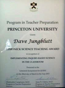
Lemonick Science Teaching Award: Dave Jungblut, Oakcrest High School in Mays Landing, NJ, received a $50 award for his lesson entitled, Water and Air Pollution. His students will research water and air pollution problems and develop a model or experiment to support their research. Dave will use the award money to fund the student projects.
American Geophysical Union (AGU) Author Presentation
American Geophysical Union (AGU) Author Presentation Poster
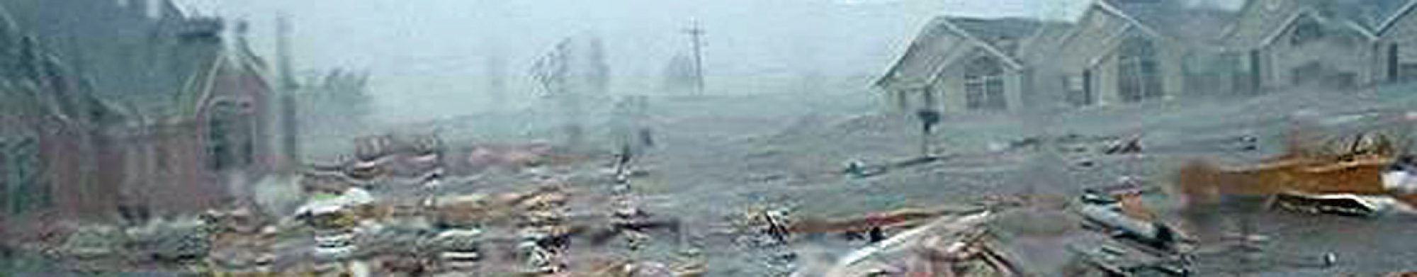
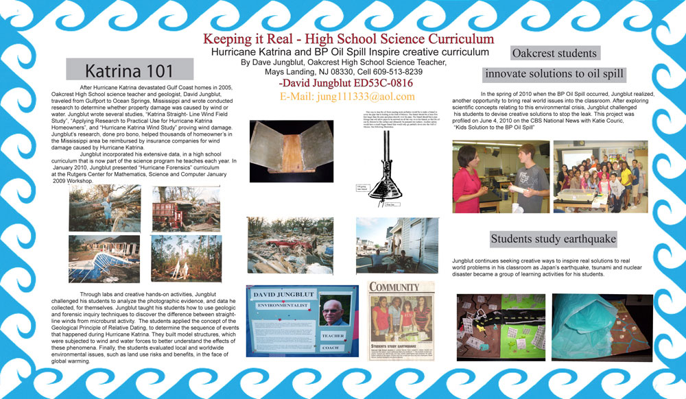
After Hurricane Katrina devastated Gulf Coast homes in 2005, Oakcrest High School science teacher and geologist, Dave Jungblut, traveled from Gulfport to Ocean Springs, Mississippi and conducted research to determine whether property damage was caused by wind or water. Jungblut wrote several studies, “ Katrina Straight-Line Wind Field Study”, “Applying Research to Practical Use for Hurricane Katrina Homeowners”, and “Hurricane Katrina Wind Study” proving wind damage. Jungblut’s research, done pro bono, helped thousands of homeowner’s in the Mississippi area be reimbursed by insurance companies for wind damage caused by Hurricane Katrina.
Jungblut incorporated his extensive data, in a high school curriculum that is now part of the science program he teaches each year. Jungblut presented “Hurricane Forensics” curriculum at the Rutgers Center for Mathematics, Science and Computer January 2008-2009 Workshop. Through labs and creative hands-on activities, Jungblut challenged his students to analyze the photographic evidence, and data he collected, for themselves. Jungblut taught his students how to use geologic and forensic inquiry techniques to discover the difference between straight-line winds from microburst activity. The students applied the concept of the Geological Principle of Relative Dating, to determine the sequence of events that happened during Hurricane Katrina. They built model structures, which were subjected to wind and water forces to better understand the effects of these phenomena, Finally, the students evaluated local and worldwide environmental issues, such as land use risks and benefits, in the face of global warming.
In the spring of 2010 when the BP Oil Spill occurred, Jungblut realized, another opportunity to bring real world issues into the classroom. After exploring scientific concepts relating to this environmental crisis, Jungblut challenged his students to devise creative solutions to stop the leak. This project was profiled on June 4th, 2010 on the CBS National News with Katie Couric, “Kids Solution to the BP Oil Spill” continues seeking creative ways to inspire real solutions to real world problems in his classroom as the Japan’s earthquake, tsunami and nuclear disaster became a group learning activities for his students.
2012 AGU-NESTA Geophysical Information For Teachers (GIFT) Workshop Presentation
AGU FALL MEETING 2013
AGU FALL MEETING 2013, EXPLORATION STATION BOOTH 6, DECEMBER 8, 2013 MOSCONE CENTER-GATEWAY HALL, SAN FRANCISCO, CA
David Jungblut1, Julianne M. Winters2, Anne N. Catena3, and Daniel I. Rubenstein4 1Oakcrest High School and Atlantic Cape Community College Dept. Math and Science, Mays Landing, NJ 2Dept. of Biodiversity, Earth and Environmental Science, Drexel University, Philadelphia, PA 3 Program in Teacher Preparation, Princeton University, Princeton, NJ 4Dept. of Ecology and Evolutionary Biology, Princeton University, Princeton, NJ
It is a misconception that when teachers incorporate research into their classroom that they are unable to cover the necessary, required curriculum material. To the contrary, when working with real scientific data, students are in fact exposed to more material, not less. Here, the scientific method is used as a flexible tool – inspiring and helping students to properly order their thinking processes. Through Princeton’s Program in Teacher Preparation, and specifically the QUEST program, teachers are taught two very important tools towards leading research-based classrooms; reflections and inquiry-based questioning. In particular, these skills allow teachers to bring research into the classroom year after year, building their students research prowess and critical thinking skills. A QUEST graduate, Mr. David Jungblut, will present how he has incorporated reflection and inquiry-based learning into his classrooms studying local storms and hurricanes, such as Derecho, Katrina and Sandy. Through his activity, participants will be guided through question generation and then work together to find the imperative answers about why and how these storms occur and how they can affect natural systems. By teaching how to ask questions and reflect on their observations first, Jungblut has found his students now approach him first with questions after major storms, instead of having to initiate the conversation himself. Students are intrigued to decipher why their homes may have been flooded, while their neighbors remain dry, for example – an answer they can’t find in a textbook or search for online, yet are excited to tackle thanks to the confidence instilled in them through learning the scientific method.
1:15 Teacher/Parent Forum: How to identify individual animals in a group? Why is identifying individuals in a group important? What are keystone species?
1:30 K-5: How to identify individual animals in a group? Zebra, Fish, Turtles, and Starfish
The devastating Hurricane Sandy made landfall on the Jersey Shore on Monday October 29, 2012. The pictures and video of the storm taken by a fellow teacher who rode out the storm springboard a classroom discussion on how Hurricane Sandy effected the east coast of the United States.
Hurricane Sandy Reflections and Experiences with Weather
Teachers and staff at Oakcrest High School openly discuss their personal experiences with Hurricane Sandy before, during and after the storm that caused major damage to the Jersey Shore.
Research, reflections and student solutions to the BP Oil Spill in the Gulf of Mexico. CBS National News with Katie Couric profiled this classroom project on June 4th, 2010, “Kids Solution to the BP Oil Spill”.
Geological Principles Used During My Hurricane Katrina Field Research
Geological Principles that Apply to the Hurricane Katrina Study
When geologists study rock strata, they used direct observation with geological principles to determine relative age of the rocks or an event within the rock record. When I investigated Hurricane Katrina debris, I relied on these Geological Principles of Relative Dating to explain the order the events that happened during this destructive hurricane.
One, Geological Principles of Relative Dating is called Original Horizontal. In sedimentary investigations geologist can determine events that took place. An example is when rock layers are formed flat or original horizontal, and at a later time the rock layer is uplifted. The debris field left over from this hurricane was sedimentary. Although, I had to deal with debris from cars, trucks, houses, trees, rocks and sand.
A second, Geological Principle of Relative Dating is called superposition. Superposition helps to determine relative age by stating that the different layers were deposited at different times. The older layer is lower than the younger layer on top of it. In the above picture A is younger than B. Geologists can often determine yearly events due to seasonal changes as well as current and wind direction within sedimentary rock. I use this technique to order the events that took place during Hurricane Katrina by examining the sediment (debris field).
The third, Geological Principle of Relative Dating is called cross-cutting. Cross-cutting is an exception to the superposition principle because faulting or igneous intrusion can cut into existing rock. The cross-cut event is younger than the rock it cuts. See drawing below. I used this technique to determine the order of the events and the direction the tractor-trailer boxes moved over the lot.
The last Geological Principle of Relative Dating that I used was inclusion. Inclusion recognizes that under curtain conditions rock strata that has igneous rock under it may be older or younger, but if pieces of rock are mixed with the above sedimentary rock, it was weathered from the rock below and now part of the new rock above. I used this technique to determine that the tractor-trailer box ran over the house during Hurricane Katrina. Since part of the house become part of the wheel, the house was weathered when the tractor-trailer box run into it. Both the house and the tractor-trailer box became one piece of sediment that was deposited together.
Suggested Reading and Web Sites:
http://www.answers.com/topic/relative-dating
Taxonomic Website
http://www.ucmp.berkeley.edu/help/taxaform.html
Geologic Time
Conceptual Physical Science-Explorations, Hewitt, Suchocki and Hewitt Published by Addison Wesley 2003
http://www.ucmp.berkeley.edu
http://www.geo.ucalgary.ca/~macrae/timescale/timescale.html
Extinction Information
http://www.firstscience.com
Evidence of Glaciation
http://www.geol.umd.edu Paleomap Project
http://www.scotese.com/
Scientific Methodology for Study on Wind and Water Damage During Hurricane Katrina
Scientific Methods Used for Hurricane Katrina Research.
The damage inflicted by Hurricane Katrina was by far greater than any other hurricane in the recorded history of the United States of America. Why were so many properties destroyed during Hurricane Katrina? While the institutional reasons (failed levees, destruction of delta wetlands, etc.) for the vast flooding will be debated for years, the meteorological causes for the storms intensity can be traced to the following:
One, the storm hit during high tide
Two, the intensifying low-pressure Category IV/V storm, Hurricane Katrina, was moving northwest when it hit land
Three, a blocking high was moving from the west to the east over Texas, Louisiana and Mississippi which resulted in the hurricane changing directions
Four, the hurricane environment changed from a low friction, wet environment to a high friction, dry environment.
Five, the combination of the events 1-4 resulted in the extreme high flooding and the released of massive amount of stored energy in the form of downbursts.
Downbursts are wind events that happen when the atmosphere is unstable and the air literally falls from the sky. The best way to understand what downbursts is to compare them to tornadoes. Both downbursts and tornadoes can have touchdown vortexes and paths of destruction with similar wind speeds. Tornadoes vortexes spiral upward into the atmosphere. Downbursts vortexes spiral downward to the ground. Tornadoes paths are formed by the air turning into wind as it is pulled into a vortex. Downbursts paths are formed by air pushed into straight-line winds that radiate outward from the vortex. Downbursts are formed by the downward movement of air; tornadoes are formed by the upward movement of air. In summary, downbursts are almost the exact opposites of tornadoes. Tornadoes move air upward while downbursts, move air downward.
During my scientific investigation of properties, I found evidence that led me to conclude that downbursts were happening with great frequency during this hurricane. Downbursts that are less than four kilometers in size are called microbursts. Downbursts can be over four kilometers and are called macrobursts. I have documented a number of microbursts in Mississippi and I believe that macrobursts may have occurred during Hurricane Katrina.
Conclusions from Gulfport Mississippi to Ocean Springs Mississippi by Geologist David Jungblut Teacher at Oakcrest High School in New Jersey:
Hurricane Katrina damaged the area from Gulfport to Ocean Springs, Mississippi, because the wind and water energy was released from different directions.
As the hurricane approached landfall, it cut off the normal flow of water. Flooding of low-lying areas resulted, eventually causing a backward flow of water upstream.
The direction of this type of flooding would be determined by the topography of the land. As Hurricane Katrina moved closer, the normal hurricane wind circulation or “horizontal winds” started.
In this area of Mississippi, the horizontal winds hit from the southeasterly direction.
As the horizontal winds blew over the Gulf of Mexico’s surface, wind-driven waves resulted, hitting this section area of Mississippi, from the same direction as the horizontal wind was blowing, i.e., from the southeast. Since Hurricane Katrina’s eye hit west of this area, the storm surge flooding resulted from the southwesterly direction.
Multipliable directional winds also struck during Hurricane Katrina from numerous downbursts.
Downbursts can develop into tornadoes or, over water, into waterspouts and, to a lesser degree, mini-swirls and gustnadoes.
Straight-line winds are the normal result of the downburst winds as they radiate outward from the touchdown area.
Downbursts are wind events that happen when the atmosphere is unstable and the air literally falls from the sky.
Numerous microbursts happened from Gulfport to Ocean Springs.
Microbursts are downbursts that are less than four-kilometer winds. Macrobursts are larger.
The evidence can be summarized in outline form:
I. Hurricane wind circulation from southeasterly direction A. Wind damage from horizontal winds B. Wind-driven waves’ damage
II. Multi-directional winds damage A. From tornadoes B. From mini-swirls C. From gustnadoes D. From downbursts E. From microbursts F. From macrobursts G. From straight-line winds
III. Sedimentary evidence deposits A. Debris from low-lying areas flooding depends on the topography. B. Causes of moved debris from southeasterly direction
1. Horizontal winds 2. Wind-driven waves C. Southwesterly direction resulted from storm surge. D. Causes of other directional damage 1. Tornadoes 2. Mini-swirls 3. Gustnadoes 4. Downbursts 5. Microbursts 6. Macrobursts 7. Straight-line winds E. Receding water