Copyright © 2006, 2009, 2010 by David Jungblut. All rights reserved. No part of this publication may be reproduced or distributed in any form or by any means, or stored in the database or retrieval system, without prior written permission of David Jungblut, Ocean City, New Jersey.
Why Did the New Orleans Levees Fail?
By Geologist David Jungblut
The thesis advanced in this article will show recently-uncovered evidence indicating that downburst energy, in the form of microbursts, generated straight-line winds and could have been part of the mechanisms resulting in the failure of the New Orleans levees during Hurricane Katrina.
Why did the New Orleans-area levees fail? This is one question left unanswered, even after an extensive review by the federal government was published in “Technical Note 1476: Performance of Physical Structures in Hurricane Katrina and Hurricane Rita: A Reconnaissance Report”, by the National Institute of Standards and Technology (NIST). The NIST report stated: “The mechanisms should be fully investigated using rigorous models and experimental analysis before firm conclusions can be drawn.” I suggest that the models will be inconclusive unless microburst and straight-line energy are taken into account in the models with the equivalent level amount of energy level that my study indicates. Microburst (a downburst that is smaller than 4 Km in size) and straight-line energy were part of Hurricane Katrina’s assault on Mississippi, and the following evidence will show that microburst and straight-line energy were part of the storm that hit New Orleans and surrounding areas, as well, and a possible factor in the destruction of the levees.
The following map shows the location of a series of photographs that depict storm damage in the New Orleans-area.
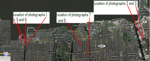
The following series of photographs that depict storm damage in the New Orleans-area, with annotations presented following each photograph:
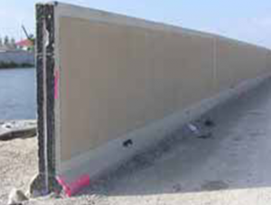
Photograph 1: View of the breach at the 17th Street Outfall Canal (Credit: Page 83, NIST TN 1476, Reconnaissance Report – Hurricanes Katrina and Rita)
The 17th Street Outfall Canal carries discharged water from Jefferson Parish and New Orleans Parish to Lake Pontchartrain. The concrete levee system was beached at N30 00.972 latitude W90 07.239 longitude; this beach caused extensive flooding of New Orleans Parish. The flood protection wall in this photograph looks to be unaffected and shows no signs of stress due to the hurricane, but the next section is missing.
Can water alone place stress on one section of levee and the adjoining section unaffected? Water alone cannot do that, however, wind can cause just this effect in the form of straight-line winds from microbursts. The jet-like currents of air can impact a discrete area and leave nearby areas unaffected. Searching National Oceanic and Atmospheric Administration’s (NOAA) Hurricane Katrina images at noaa.gov, one can locate evidence that microbursts and associated straight-line winds were active during Hurricane Katrina as shown in the next photograph near the breach at Jourdan Road.
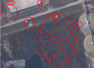
Photograph 2: View of a microburst area on Jourdan Road between Morrison and Dwyer Road near the Inner Harbor Navigation Canal (Credits: NOAA Image 24425508 and analysis by David Jungblut)
The large red circle painted on the NOAA image, shows a microburst (a downburst that is smaller than 4km). The red lines show the star-burst pattern in which the trees fell; this indicates that multiple wind directions were present during Hurricane Katrina. The small circle lines indicated damage to the surrounding buildings, along with possible ground damage to the road embankment on Jourdan Road. A close up of the area shows the trees falling in multiple directions.
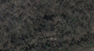
Photograph 3: A close up of the microburst area on Jourdan Road between Morrison and Dwyer Road near the Inner Harbor Navigation Canal (Credits: Google-Imagery and U.S. Geological Survey, map data)
The next photographs (#4 to #6) were taken between the breach that occurred at 17th Street Outfall Canal (See Photograph 1) and Lake Pontchartrain.
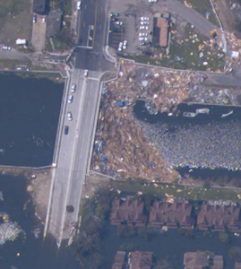
Photograph 4: 17th Street Outfall Canal close to Lake Pontchartrain (Credits: NOAA Image)
The area took a heavy beating during Hurricane Katrina with debris hitting the walls of the levees and the bridge as shown in Photograph 3. The bridge and levees in this area acted as a dam that blocked the inward flow of debris, but both the bridge and levee walls in this area held up well and were not breached.
Closer inspection reveals that some buildings in the area did suffer damage from strong winds, as seen the Photograph 5.
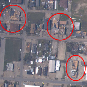
Photograph 5 (Credits: NOAA Image and analysis by David Jungblut)
The circled buildings show evidence of strong wind damage: the tin roofs of the buildings in the lower right were peeled back; the roof of the one middle building was also peeled back and the other middle building shows multiple-direction wind damage; and the building in the upper left looks to have taken a direct hit from a small microburst causing three fourths of the building to be “blown” apart with debris scattered on three sides.
The next photograph shows that the breach at 17th Street Outfall Canal and the surrounding neighborhood experienced wind damage.
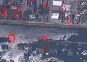
Photograph 6 (Credits: NOAA Image and analysis by David Jungblut)
Photograph 6 shows the heavy flooding flowing into New Orleans Parish at the breach. Some of the buildings just north of the breach show roof damage that can be attributed to strong winds.
Further south near one of the two breaches at London Avenue, two other buildings were “blown apart” with debris scattered in three directions, as if a small microburst hit them. See Photographs 6 and 7.
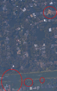
Photograph 7 and 8(Credits: NOAA Image and analysis by David Jungblut)
In photograph 7, the large circle shows the breach at London Avenue and the upper right circle shows the house that experienced a microburst. Photograph 8 shows another house that was hit by microburst energy, demonstrating that high winds were active in the area during Hurricane Katrina. Applying the Fujita Tornado Damage Scale (with the appointed damage as a guide), we can estimate the wind speed at 207 to 260 miles per hour. The Fujita Tornado Damage Scale is provided at the end of this document.
It is legitimate to query: If these houses experienced downburst winds could these same winds have impacted the levee system? The following warning was indeed issued on the day Hurricane Katrina approached.
http://www.srh.noaa.gov/data/warn_archive/LIX/TOR/0829_133900.txt
000
WFUS54 KLIX 291337
TORLIX
LAC051-057-071-075-087-089-291400-
/O.NEW.KLIX.TO.W.0090.050829T1336Z-050829T1400Z/
BULLETIN – EAS ACTIVATION REQUESTED
TORNADO WARNING
NATIONAL WEATHER SERVICE NEW ORLEANS LA
836 AM CDT MON AUG 29 2005
THE NATIONAL WEATHER SERVICE IN NEW ORLEANS HAS ISSUED A
* TORNADO WARNING FOR CATASTROPHIC WINDS FOR…
JEFFERSON PARISH IN SOUTHEAST LOUISIANA
THIS INCLUDES THE CITIES OF…TIMBERLANE…METAIRIE…MARRERO…
KENNER…HARVEY…AVONDALE
LAFOURCHE PARISH IN SOUTHEAST LOUISIANA
THIS INCLUDES THE CITY OF CUT OFF
ORLEANS PARISH IN SOUTHEAST LOUISIANA
THIS INCLUDES THE CITY OF NEW ORLEANS
PLAQUEMINES PARISH IN SOUTHEAST LOUISIANA
THIS INCLUDES THE CITIES OF…PORT SULPHUR…BELLE CHASSE
- BERNARD PARISH IN SOUTHEAST LOUISIANA
THIS INCLUDES THE CITY OF CHALMETTE
- CHARLES PARISH IN SOUTHEAST LOUISIANA
* UNTIL 900 AM CDT
* AT 832 AM CDT…MANY REPORTS ARE COMING IN STATING TOTAL
STRUCTURAL FAILURE IN THE NEW ORLEANS METRO AREA.
SEEK SUBSTANTIAL COVER NOW!!! THIS IS A LIFE-THREATENING SITUATION.
A TORNADO WATCH REMAINS IN EFFECT UNTIL NOON CDT MONDAY FOR SOUTHEAST
LOUISIANA AND SOUTHERN MISSISSIPPI.
LAT…LON 2945 9036 2948 8953 3008 8922 3004 9040
(emphasis added)
Coinciding with these catastrophic wind warnings, three of the nine levees failed at about 9am. The others followed within the next 24 hours. The words in the warning seem to indicate the winds could have caused “STRUCTURAL FAILURE IN THE NEW ORLEANS METRO AREA” affecting all the levees during the “8:32 AM CDT” reporting window or immediately after.
In conclusion, the science of microburst and straight-line winds are a relatively new field of inquiry and not known to exist until Dr. T. Theodore Fujita described microburst and straight-line winds in the 1970’s. The models that explain why the levees failed will be inconclusive unless microburst and straight-line energy is incorporated at the correct levels of energy within to the models. The evidence indicates that microburst and straight-line winds speeds of 207 to 260 could have caused the walls of levees to fail.
Fujita Tornado Damage Scale
Developed in 1971 by T. Theodore Fujita of the University of Chicago
| SCALE | WIND ESTIMATE *** (MPH) | TYPICAL DAMAGE |
| F0 | < 73 | Light damage. Some damage to chimneys; branches broken off trees; shallow-rooted trees pushed over; sign boards damaged. |
| F1 | 73-112 | Moderate damage. Peels surface off roofs; mobile homes pushed off foundations or overturned; moving autos blown off roads. |
| F2 | 113-157 | Considerable damage. Roofs torn off frame houses; mobile homes demolished; boxcars overturned; large trees snapped or uprooted; light-object missiles generated; cars lifted off ground. |
| F3 | 158-206 | Severe damage. Roofs and some walls torn off well-constructed houses; trains overturned; most trees in forest uprooted; heavy cars lifted off the ground and thrown. |
| F4 | 207-260 | Devastating damage. Well-constructed houses leveled; structures with weak foundations blown away some distance; cars thrown and large missiles generated. |
| F5 | 261-318 | Incredible damage. Strong frame houses leveled off foundations and swept away; automobile-sized missiles fly through the air in excess of 100 meters (109 yds); trees debarked; incredible phenomena will occur. |
During the summer of 2005, David Jungblut spent time in New Orleans as Hurricane Katrina approached and later did a scientific investigation into the damage that the hurricane inflicted because homeowners’ insurance claims were being rejected. Insurance companies claimed that all damage was due to flooding and not wind. David Jungblut pointed out that wind damage was visible. He wrote reports about his findings, all pro bono. Later he posted his findings at http://www.hurricanekatrinastudy.com/ that was available to homeowners, engineers and lawyers free of charge.
David Jungblut has a degree in Geology from Livingston College, Rutgers University. He worked for the United States Geological Survey focusing on stream flow hydrology for three years. David has done environmental consulting for radon and environmental sensitive land development in New Jersey. He spent time working in water and sewer treatment plants. For the past 21 years, he has taught science at Oakcrest High School in Mays Landing, New Jersey.
David Jungblut can be contacted at 1824 Dr. Foreman Drive
Mays Landing, NJ 08330, Phone 609- 399-5845 or by E-mail: davidjungblut@hurricanekatrinastudy.com , djungblut@geh.nj.k12us.com
Peer review was done by Joe Hochreiter, senior environmental scientist from Yardley, Pennsylvania.
Confidentiality – Avis de confidentialite
The information transmitted is intended only for the addressee and may contain confidential and/or proprietary material. Any unauthorized review, distribution or other use of this information, or the taking of any action in reliance upon this information, is prohibited. If you received this in error, please contact the sender and delete or destroy this message and any copies.

